
Welcome to the Groton trails system. Groton has over 10 square miles of conservation land with roughly 130 miles of maintained trails. Explore lakes, eskers, oxbows, drumlins, kettle holes, rivers & streams, vernal pools, fields, hills, farms, swimming holes, and beaver dams. While exploring, you will also observe extremely diverse populations of wildlife, trees, bushes, wildflowers, insects, fungus, and more. The navigation bar has an interactive map of the trails and a list of suggestions for fun trail activities. To contact us, go to our About Us page.
To celebrate the 25th year of the Groton Trails Committee, we've put together a list of 25 Places of Special Interest on the trail system. Visit all 25 places by the end of the year and you’ll receive an award. Click or touch here for more information.
The friends of the Groton Trails Network would like to thank the many landowners that make our wonderful trails network possible: Groton Conservation Commission, Groton Conservation Trust, New England Forestry Foundation, Mass Audubon, Mass Department of Conservation and Recreation, and Groton Water Department, Town Forest Committee, Mass Wildlife, and others
After exploring our trail network, check out the trails in the towns surrounding Groton. Littleton Conservation Trust, Westford Conservation Trust, Nashoba Conservation Trust (Pepperell), Dunstable Trail Maps, Dunstable Rural Land Trust, and Townsend Trail Map.
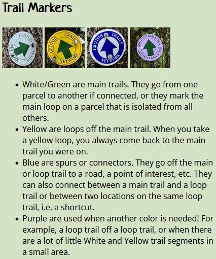
If you are unsure of anything regarding the trails, take a look at our Trail Use Guidelines.